
According to the DJI Agriculture Annual Report, as of 2024, more than 300,000 agricultural drones operate globally, treating more than 500 million hectares of farmland around the world due to aerial imaging technology. The industry undergoes significant digital transformation. The sheer number of IoT and drone devices in use indicates that eventually, most businesses will rely on technology more. So, what should you expect, and how can you get started with aerial imaging in farming?
In this post, you’ll explore the concept of aerial imaging in farming, find out about technology use cases, and discover what devices are needed to make it work. Besides, you’ll review success stories of farm management with aerial imaging and get to know this technology’s limitations and solutions to them.
Need High-Precision Imaging Solutions with Computer Vision?
Get consultation
8 benefits & use cases of aerial imaging in agriculture
Above everything, let’s recap what we know about aerial imaging:
Aerial imaging is the process of capturing images of land or crops from above using drones, satellites, or aircraft.
Basically, aerial mapping in agriculture is becoming a common replacement for the labor-driven process of visual examination of crops, equipment, facilities, etc. In a similar way, it’s also used across other domains.
Explore computer vision applications in industries in another of our blog posts.
Now, when we are familiar with the main concept of the topic, let’s proceed by reviewing actual use cases of aerial imaging in farming:
#1 Crop health monitoring
Aerial imaging captures multispectral and thermal data to identify stressed, diseased, or pest-affected areas in crops. Farmers use the imagery to locate problem zones without walking the entire field.
Best for:
Large-scale farms, horticulture producers, vineyards, specialty crop growers.
Suggested frequency of data collection:
Every 7–14 days during the growing season or after major weather events.
Deliverables:
Vegetation index maps, thermal stress maps, crop health reports.
#2 Soil analysis and field mapping
Aerial imaging creates soil maps by capturing visual and multispectral data on soil moisture, texture, and composition. These maps help define field zones for management and planting.
Best for:
Crop farms, seed producers, precision agriculture companies.
Suggested frequency of data collection:
Once per season before planting and as needed after major field changes.
Deliverables:
Soil variability maps, moisture distribution models, planting prescription maps.
#3 Irrigation management
Thermal imaging identifies areas of fields that are under- or over-watered. Data from aerial scans highlights zones needing irrigation adjustments.
Best for:
Orchards, vegetable farms, greenhouse operations, arid-region farms.
Suggested frequency of data collection:
Every 10–14 days during peak irrigation periods.
Deliverables:
Thermal imaging maps, water stress distribution reports, irrigation adjustment guides.
Don’t hesitate to reach out to us for technology consulting services.
#4 Precision spraying and fertilization
Aerial imagery is used to create variable-rate maps for site-specific application of pesticides or fertilizers. This targets exact field areas needing treatment instead of sticking with uniform application.
Best for:
Row crop farms, vineyards, organic farms, seed producers.
Suggested frequency of data collection:
Pre-treatment mapping and follow-up imaging after spraying or fertilization.
Deliverables:
Prescription maps for spraying, fertilizer application maps, treatment validation imagery.
#5 Yield estimation
Vegetation indices and canopy data captured by aerial imaging are analyzed to estimate the expected crop yield. Farmers implement the insights to plan harvest logistics and predict production volumes.
Best for:
Grain producers, fruit orchards, agribusiness corporations.
Suggested frequency of data collection:
Two to three times per season: mid-growth and pre-harvest.
Deliverables:
Biomass maps, canopy cover models, predicted yield reports.
#6 Disaster assessment
After natural disasters like floods or storms, aerial imaging documents damaged field areas. This helps farmers assess field conditions without risking in-person inspections.
Best for:
Mixed crop farms, insurance partners, and government-supported farming programs.
Suggested frequency of data collection:
Immediately after the disaster event and one follow-up survey 7–14 days later.
Deliverables:
Damage assessment maps, affected area calculations, insurance documentation photos.
Find out about an extra application of data science in business from another blog post by Intelliarts.
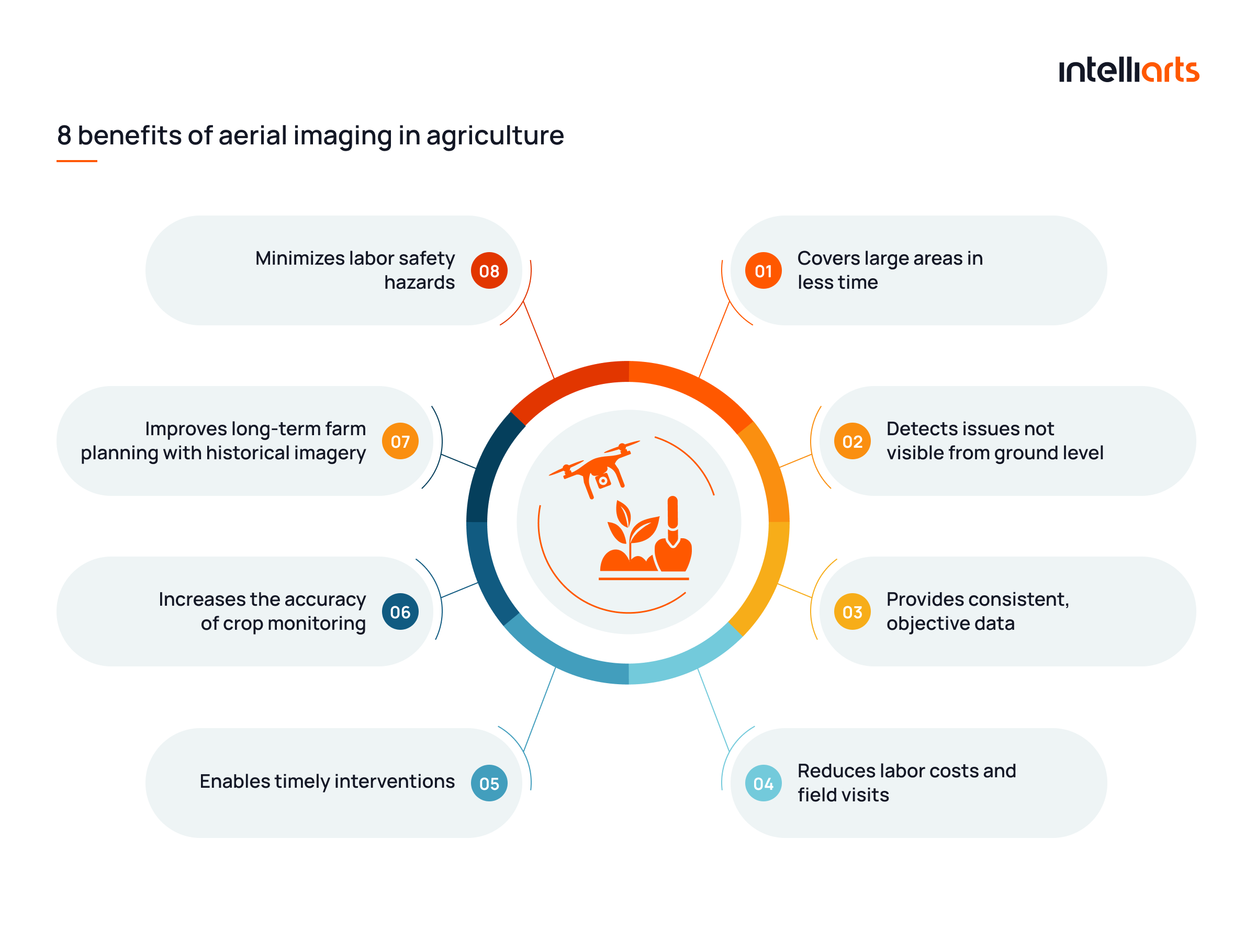
What’s also useful to know is how beneficial the usage of aerial imagery in agriculture is compared to manual labor. 8 exact benefits of aerial imaging in farming are provided in the image below:
Digital technologies driving aerial imaging
Aerial mapping in agriculture is grounded on a combination of smart and conventional technologies. But before we delve deeper into their overview, let’s take a brief look at how aerial crop imaging works in the infographics below: 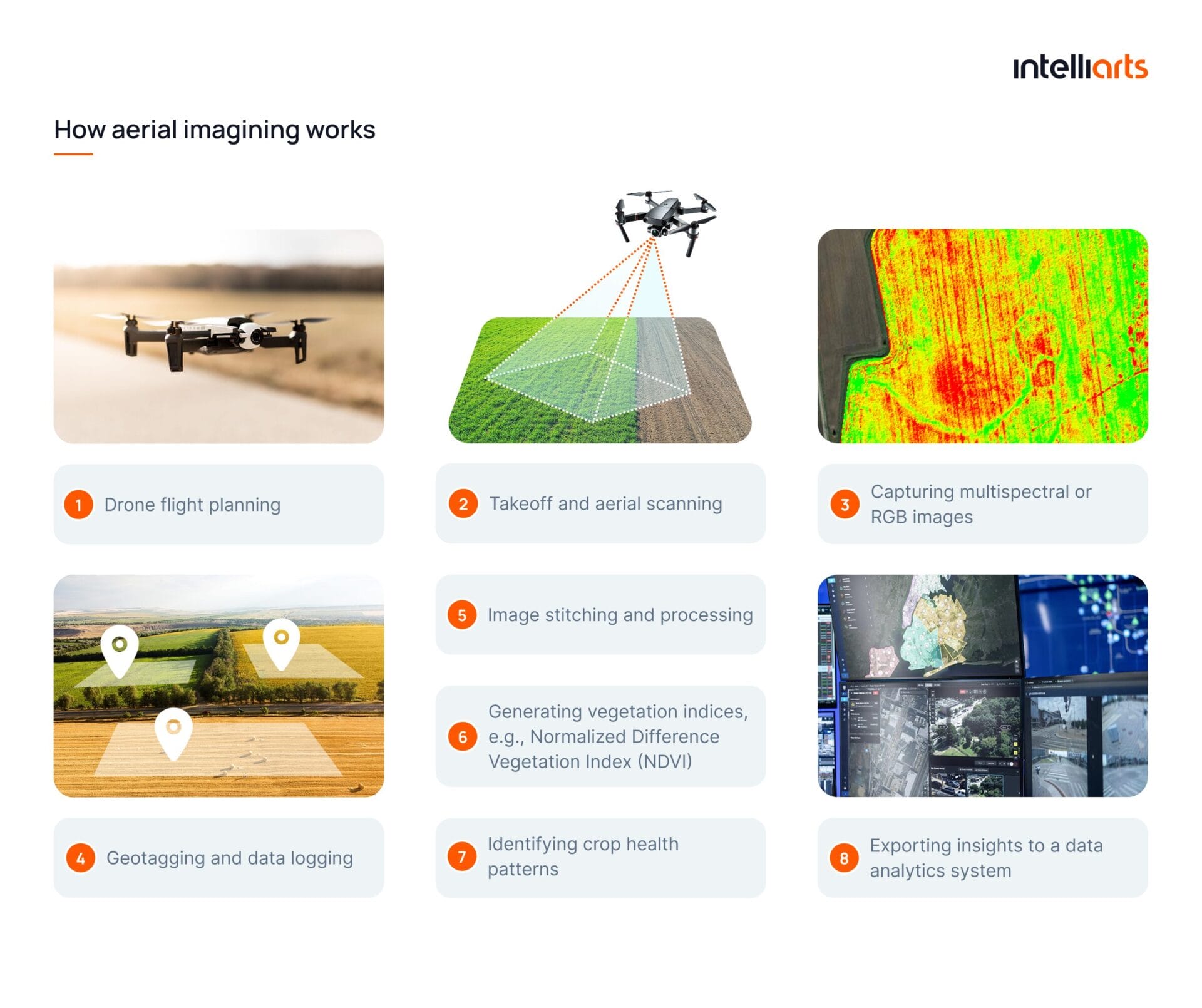
Computer vision is also used in a number of other niches. Discover in-depth details on solar panel fault detection and test an actual ML model demo yourself in another Intelliarts’ blog post.
Note: Steps six and seven are optional. That’s because crops may not be present or visible during a particular flight, which may happen, for example, in winter. On such occasions, neither NDVI nor crop health patterns can be examined. Alternatively, aerial data for smart farming may be examined by the very data analytics system instead. In this scenario, the role of a drone and integrated imaging technology is only to capture, tag, and transfer data.
And now, here’s the list of digital technologies behind aerial imaging and examples of software solutions available on the market:
#1 Computer vision
This technology is needed to enable automatic detection of patterns, crop health issues, and land features from aerial images.
Examples: TensorFlow, OpenCV
#2 Artificial Intelligence (AI)
In this case, AI powers smart analysis of aerial imagery to detect diseases, predict yield, and optimize farming strategies.
Examples: Microsoft Azure AI, IBM Watson Decision Platform for Agriculture
#3 Machine learning (ML)
ML is needed to train models to recognize crop types, estimate biomass, and improve predictions over time from aerial data.
Examples: Amazon SageMaker, Google Vertex AI
Explore custom machine learning solutions by Intelliarts.
#4 Cloud computing
Cloud solutions, as an alternative infrastructure option, enable to store, processing, and access to large aerial datasets and maps from any device.
Examples: AWS Cloud for Agriculture, Microsoft Azure FarmBeats
#5 Edge computing
Edge computing is an optional solution that’s needed to process aerial images directly on drones or nearby edge devices to deliver fast insights without full cloud upload.
Examples: NVIDIA Jetson, Microsoft Azure Percept
#5 Geospatial data analysis (GIS)
GIS allows for mapping aerial data spatially to support decision-making in field zoning, irrigation, and fertilization.
Examples: ESRI ArcGIS, QGIS, DroneDeploy
#6 Wireless communication (4G/5G)
Communication drives real-time data transmission between drones, ground stations, and farm management systems.
Examples: Qualcomm 5G Modems, Telit IoT Connectivity
#7 Internet of Things (IoT)
IoT is another optional, but typically available technology in aerial imaging that connects drones with other smart farm devices (e.g., soil sensors) to create a unified monitoring ecosystem.
Examples: Bosch IoT Suite, John Deere Operations Center
Note: While a number of companies offer tailored solutions to help drive aerial imaging, the process of building an actual working software system is far more complex than simply using one or another software available. That’s why most companies without a specialized in-house dev team need external software development assistance with their aerial imaging project.
Devices used for aerial imaging
What’s also essential to know for a complete insight into the technicalities of aerial crop monitoring is the range of devices that can be utilized here. The complete overview is provided in the table below:
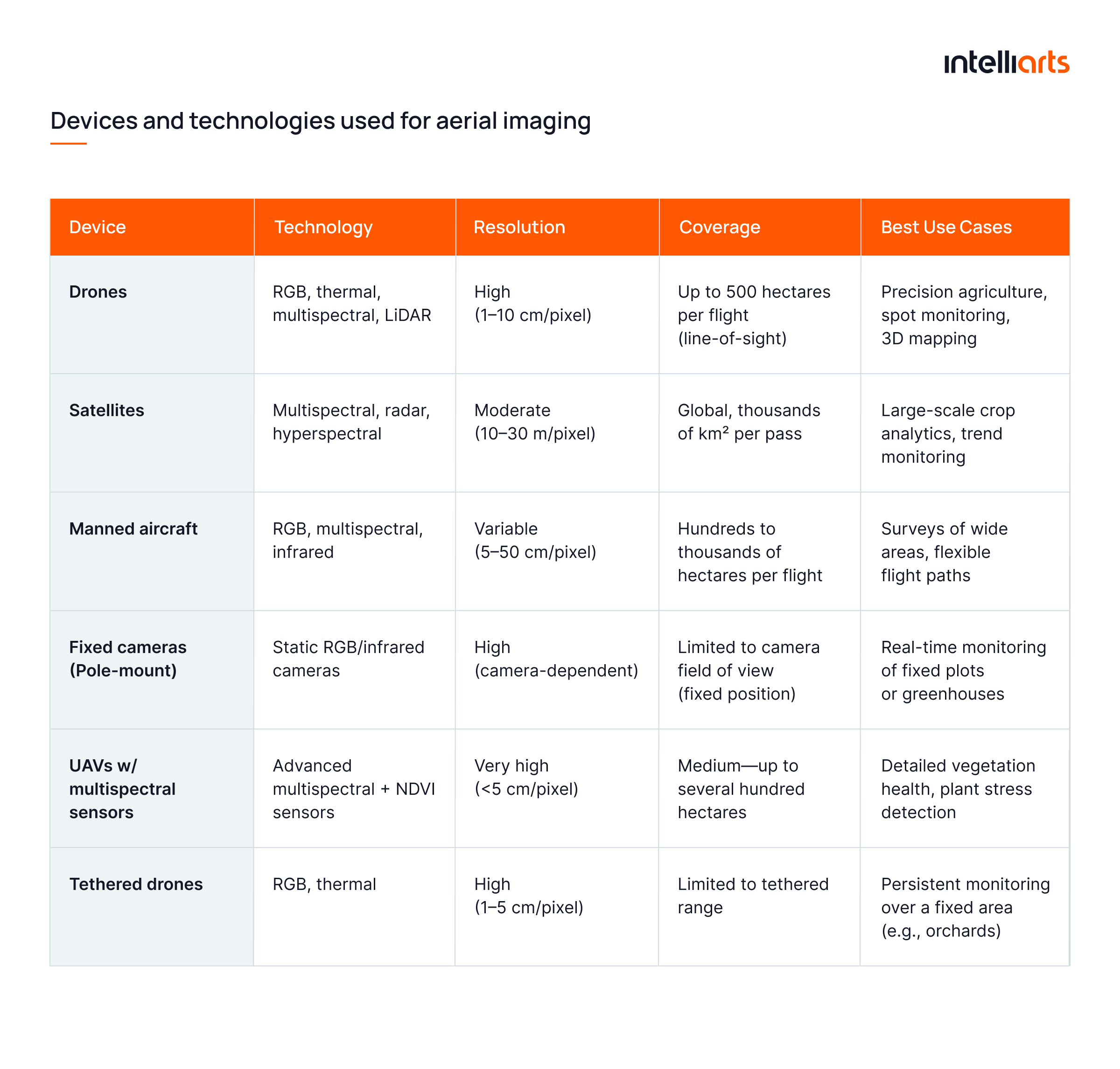
In practice, fixed cameras are one of the most widespread solutions due to their low cost of maintenance and operational simplicity. They are typically placed in greenhouses. Drones are a typical choice when there’s a need to cover a large farming area.
At the same time, sensors that can provide an overview of vegetation health are regarded as a sort of specialized equipment, used, for example, to monitor a small area inside a greenhouse. Temperature and humidity sensors are other common devices, approached similarly to fixed cameras. They are placed in most greenhouses and are sometimes in certain zones at farming fields.
You may see an example of temperature and humidity sensors placement in greenhouses in the image below:
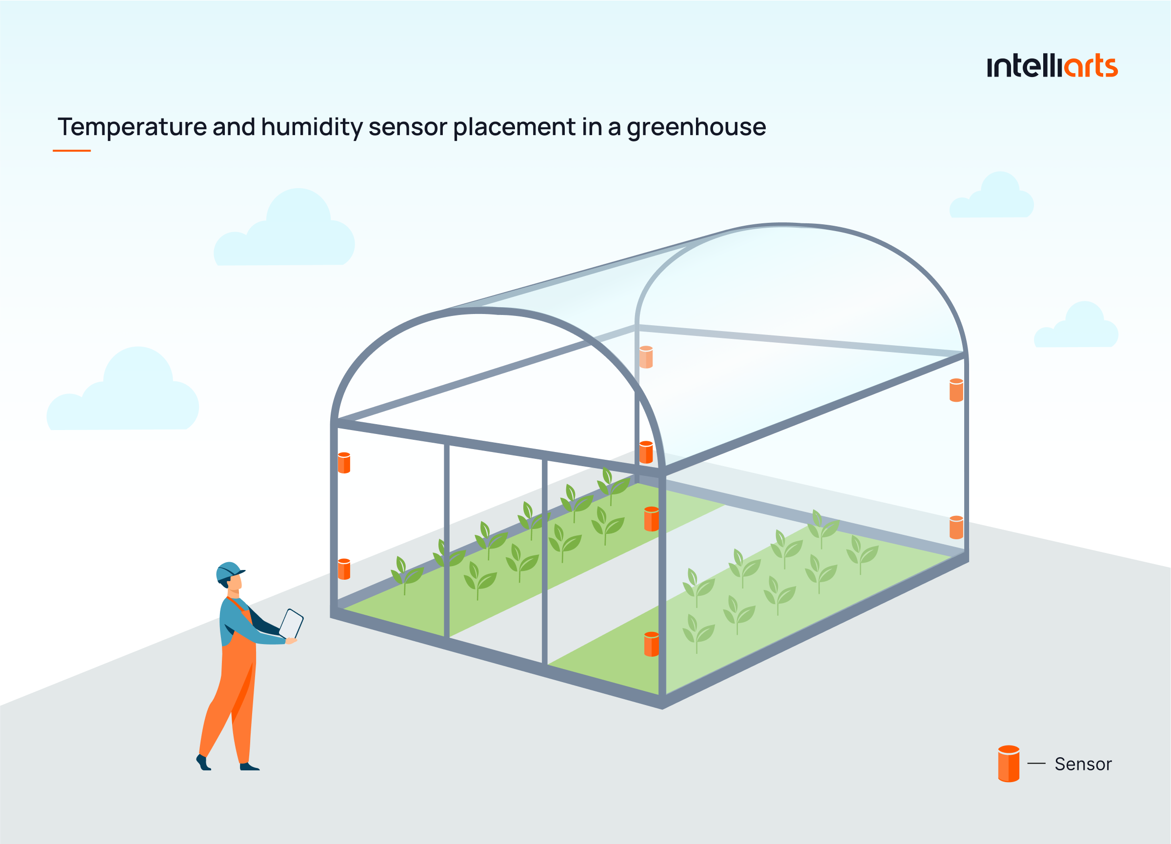
This placement is in line with ISO 17025 provisions regarding validation of data gathering methods, impact of environmental conditions on measurements, and documentation and traceability of data.
As for fixed cameras, 2 or 4 such cameras are mounted on either internal greenhouse supporting pillars or on walls so that they can capture most of the agricultural area.
Success stories of crop monitoring in agriculture
Let’s take a look at a couple of success stories where Intelliarts helped with smart technologies through agriculture software development services:
Indigo Ag’s automated data entry for carbon insights
Background: Indigo Ag faced high drop-off rates due to time-consuming manual data entry — up to 8 hours to input field data like seed types, locations, and practices — slowing adoption of their Carbon program.
Solution: Intelliarts built advanced ETL/ELT pipelines and integrations with third-party data providers to automate field data collection. By layering structured workflows with medallion architecture and FSM logic, the system now ingests and processes external agronomic data in near real-time, enabling rapid correlation with aerial imaging and environmental models.
Results: Indigo slashed data entry time from hours to minutes, improved data accuracy across systems, and saw higher user satisfaction and retention. The new infrastructure supports faster carbon credit validation and smarter, imaging-enhanced decision-making.
Indigo Ag’s automated land sampling with sensor integration
Background: Indigo Ag needed to modernize its manual land sampling process to improve data quality and support its carbon program.
Solution: Intelliarts redesigned the system using tablets, QR codes, and field sensors to automate sample collection. The platform now supports real-time data syncing with aerial imagery and enables faster, more accurate insights for agronomic analysis.
Results: Sampling time and errors were significantly reduced. Sensor losses dropped below 4 per 1,000. Indigo now benefits from standardized workflows and seamless integration of aerial and ground-level data.
Aerial imaging technology limitations & solutions
As obvious as it sounds, every technology has its limitations. To complement what we already know about sustainable farming with aerial imaging, let’s find out the challenges of using this smart approach and ways to solve them:
#1 Limited resolution
The resolution of aerial imagery is limited and may be insufficient, especially if lower-cost or simply outdated drones or sensors are used. This impacts the ability to capture fine details at large distances.
Solution: Before getting started with a project, it’s important to estimate the optimal resolution. It’s even better to try to forecast what resolution would be required in 5-10 years, and select drones and sensors that would still suffice after this period of time, instead of purchasing minimally suitable models.
Besides, using high-definition cameras and LiDAR (Light Detection and Ranging) sensors can improve resolution. As a workaround, you may consider integrating multiple image stitching techniques to enhance detail accuracy.
#2 Weather sensitivity
Aerial imaging in agriculture is heavily dependent on weather conditions. High winds, rain, and low visibility can disrupt or delay image collection.
Solution: Using drones with enhanced stabilization and weather-resistant capabilities can reduce the impact of adverse conditions. Employing multiple scheduling options is another way to find optimal weather windows.

#3 Data storage and processing
High-resolution imagery produces large datasets, which can be difficult to manage and process in a timely manner.
Solution: It’s generally recommended to use cloud-based storage solutions, which can be scaled well compared to in-house alternatives, and optimized, AI-driven processing algorithms. Building a big data pipeline is also crucial for the entire procedure of data storage and processing.
Explore the DDMR data pipeline success story to find more about Intelliarts’ experience with big data projects.
#4 Data interpretation
Processing raw aerial images manually is time-consuming. It’s also difficult to obtain a clear insight from raw data without specialized knowledge, especially when it comes to monitoring complex environments like agriculture or infrastructure.
Solution: AI and machine learning can and, as a common practice, should be used to automate the analysis and interpretation of aerial images. While there’s still an opportunity for specialists to analyze a portion of the images themselves, for example, when double-checking the results or searching for anomalies in imagery, most of the routine work should be automated.
Probably the best recommendation here, especially for non-tech companies, is to partner with trusted software engineers should you have an aerial imaging project in mind. Software agencies with experience are likely to have gone through the listed and other challenges and have ways to address them in an effective manner. They may even have some custom solutions to one or another difficulty. So, there are all the reasons to take full advantage of external expertise and experience.
Final take
Aerial imaging has firmly established itself as a critical technology in modern farming. It enables precise monitoring, smarter planning, and better decision-making across a variety of agricultural operations. From crop health analysis to disaster assessment, aerial imaging tools continue to reshape how farms operate. Understanding the technologies, workflows, and limitations involved helps businesses maximize the value of this innovative approach and prepare for a more data-driven future.
Having a trusted tech partner is half the battle. Over the span of more than 25 years, with 90% of returning customers and a team of senior staff engineers, Intelliarts can drive your aerial imaging project with our expertise and experience. Don’t hesitate to reach out to discuss opportunities.
FAQ
What is the technology used to take aerial photographs?
Aerial imaging in agriculture typically uses drones equipped with high-resolution RGB, multispectral, or thermal cameras. These technologies enable precise aerial crop imaging and deliver accurate data for farm health assessments, irrigation planning, and input optimization.
What sensors are used in agricultural drones?
Agricultural drones use multispectral, thermal, LiDAR, and RGB sensors. These sensors power aerial crop monitoring by detecting plant stress, moisture levels, and vegetation indices, supporting smarter decisions and sustainable farming with aerial imaging.
What is the use of photogrammetry in agriculture?
Photogrammetry transforms aerial imagery in agriculture into 3D field models. This allows for detailed analysis of elevation, drainage, and terrain patterns, enhancing aerial mapping for agriculture and enabling more efficient land and crop management.


![Implementing Object Detection in Business [Case Study]](https://intelliarts.com/wp-content/uploads/2021/11/65e54c_b4be1b6c2d04466a9bdc4c8246183a8amv2.webp)