
Precision agriculture brings real value when fields are treated as evolving systems. Thanks to regular satellite observations, agronomists can spot patterns invisible in a single pass. For example, research shows that medium-resolution imagery can explain 59% to 100% of within-field yield variability, depending on resolution. Over time, repeated data helps you detect trends, such as a part of the field recovering more slowly after heavy rains or a zone that always lags in growth. Repeated signals often tell more about field behavior than stress alerts.
To turn incoming remote sensing data into decisions, farmers need tools that can link satellite imagery to fieldwork, like which areas to check for pests or how to adjust fertilization. The crop monitoring software for precision farming helps teams do that consistently and get measurable outcomes.
Role of remote sensing in precision farming
Spectral remote sensing provides quantitative measurements of how crops and soils reflect electromagnetic energy across multiple wavelengths. This approach is more informative than a standard visual assessment because each spectral band or its combination correlates with specific structural or biochemical crop attributes. NDVI is the most commonly used metric in agricultural monitoring, derived from satellite imagery. It highlights early deviations in crop health but should be treated as an initial indicator rather than a full diagnostic tool.
Multispectral and hyperspectral data enable in-depth crop condition monitoring. Narrowband reflectance enables the estimation of leaf chlorophyll content, leaf area index, soil moisture, and soil type proxies, which support variable-rate input planning, crop recovery efforts, and problem-specific scouting.
In practice, effective analysis requires consistent temporal coverage, calibrated indices, and comparison against historical field profiles. While still used alongside standard techniques, AI models now analyze spectral shifts with crop stage and field context in mind, improving how we identify probable sources of anomalies.
Predictive analytics for day-to-day farm operations
Modern agricultural forecasting uses machine learning (ML) to process multiple data streams simultaneously, including satellite-derived vegetation indices, soil sensor measurements, and site-specific weather. Forecasting models combine crop monitoring data to detect pest or disease risk, identify when the next growth stage begins, or predict yields weeks before harvest with the highest precision.
When supported by biophysical modelling, these forecasts can also rank crops by expected bio-productivity. In 2021, EOS Data Analytics applied such a model in Kazakhstan using dry matter productivity datasets, Copernicus Global Land Service inputs, and NASA Power meteorology. After calibration, the model produced concrete sowing and harvesting dates and identified which crops would be the most productive that season.
However, forecasts deliver real-world results only when the farm can act on them. Variable-rate application machinery, automated irrigation systems, and drone support close the loop between prediction and response. Combining calibrated ML forecasts with field automation allows growers (especially large-scale ones) and agricultural insurers to reduce risks and shorten decision cycles, resulting in measurable business improvements.
In our work at Intelliarts, we often see that the main barrier is not the quality of the model, but the effort required to prepare and maintain the underlying data. For example, in one agritech project we helped replace weeks of manual field history entry with a “lightning” workflow that auto-prefills crop and management data using satellite imagery and internal inference APIs. In the end, we enabled growers to enroll millions of acres into carbon programs much faster.
In another case, we built ETL/ELT pipelines and software integrations that pull seed, field, and practice data directly from third-party sources, cutting data entry time from up to eight hours to just a few minutes and making predictive tools actually usable at scale.
Using satellite insights to guide field-level decisions
Precision agriculture is impossible without accurate field data that can be checked quickly and used in daily operations. Satellite imagery is ideal for this because multi-temporal data exposes both current changes and long-term patterns. The goal of satellite-based agricultural monitoring is to recalibrate plans based on real field dynamics captured through remote sensing. Farmers and agronomists can use this data to divide the field into management zones and decide where to focus scouting and increase/reduce inputs.
With reliable imagery in hand, farmers can segment a field into management zones, highlight areas with recurring anomalies, or validate whether recent interventions are producing the expected effects, among which are irrigation, fertilization, pest control. Modern crop monitoring platforms act as the “analytical layer” that organizes remote sensing signals, weather data, and field records into actionable recommendations, while field machinery and drones serve as the “execution layer.”
In practice, this “analytical layer” only works if field data and operational workflows are digitized and easy to maintain. For one agritech partner, we redesigned a legacy land sampling system so that samples are tracked with tablets, QR codes, and sensors instead of spreadsheets. This reduced manual handling, improved data quality, and ensured that lab results and remote sensing insights could be interpreted together, not in isolation.
Read the full case study how we helped automate land sampling and improve data accuracy.
Many commercial tools support this workflow by generating variable-rate application (VRA) maps based on vegetation indices, such as NDVI, NDRE, or MSAVI. These maps can be exported directly into equipment from John Deere, Trimble, or AGCO, which adjust input rates on the go. For growers, this creates a seamless path from satellite-derived insights to precise interventions at the sub-field level.

Source: EOS Data Analytics
Choosing the right spatial scale for farm monitoring
Spatial resolution remains a key design choice for any monitoring workflow:
- Broad-scale (10–30 m) satellite products are best for long-term vegetation dynamics, crop-type mapping, drought surveillance, flood risk analysis, or monitoring disturbances such as storms and fires at landscape level.
- High-resolution imagery (0.3–5 m) supports within-field diagnostics—row-level variability, nutrient deficiency zones, equipment malfunction patterns, or local weed expansion.
- Very high-resolution imagery goes even further, enabling parcel boundary refinement, compliance verification, and detailed crop or soil assessments.
Most operational systems combine multiple scales in one process: broad imagery for strategic awareness and high-resolution data for operational decisions. Platforms such as EOSDA LandViewer, Planet Explorer, and commercial UAS/orthomosaic services enable this multi-resolution workflow, while custom ML pipelines (like those we build at Intelliarts) can integrate these layers for automated anomaly detection, vegetation trend analysis, or event-driven alerting.
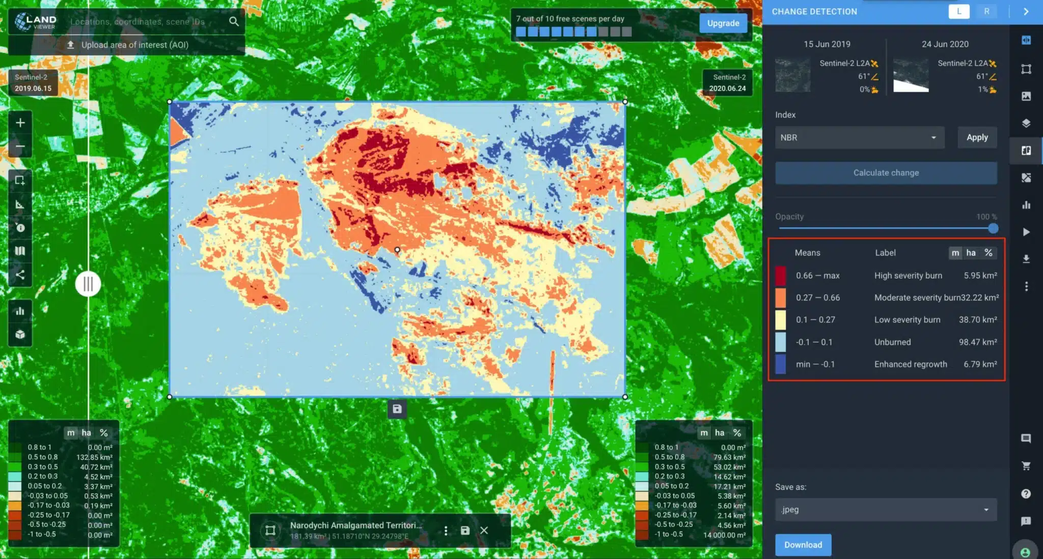
Forest fire change detection scaled | Source: EOS Data Analytics
Wrap up
As precision agriculture becomes more accessible and user-friendly, growers increasingly rely on remote crop monitoring to explain what’s happening in their fields and why. When the standard toolkit isn’t enough, tailored ML solutions, calibrated for the local climate, crop type, and operational constraints, provide the next layer of value. Satellite data, combined with predictive modeling and on-farm automation, is gradually transforming land management into a transparent, insight-driven process.
As the industry continues shifting toward data-driven farming, Intelliarts brings deep experience in agriculture software development to agritech companies and growers. We can help you solve various challenges, from automating field data collection and land sampling to building sensor management systems and ML-powered forecasting tools.
Turn satellite insights and farm data into real results
Expert custom software development for the agricultural businesses.
Let's discuss your project